Property Record
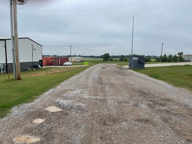
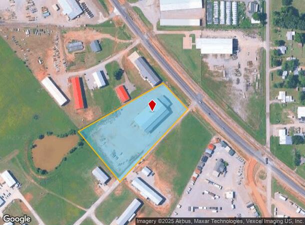
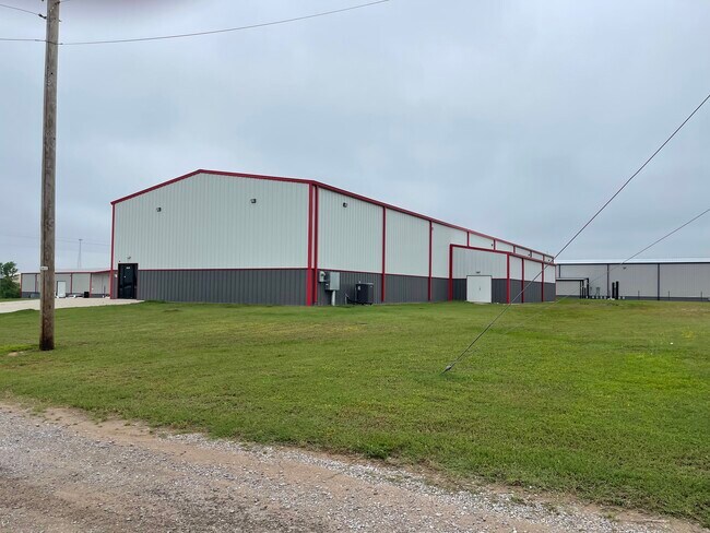
9000 S Highway 77, Noble, OK 73068
This Property Is For Sale
NEARBY LISTINGS FOR SALE OR LEASE
Property Detail
9000 S Highway 77
R0159833
2-7-2W 4.63 AC PRT SE/4 BEG 1759.65`W S 40D E851.37` NE/C SE/4 POB S 40D E416.05` N 43D E712.96` C/R (R=5779.60`) CB N 43D W206.54` S 60D W707.57` POB LESS HWY 77
Commercialnec
Cleveland
X
Oklahoma
40027C0380H
4.63 AC
2024
Southeast Outlying
2024
Oklahoma City
202501
Oklahoma City, OK
23,363 SF
DEMOGRAPHICS near 9000 S Highway 77
1 Mile
3 Mile
5 Mile
2024 Total Population
867
7,807
17,497
2029 Population
934
8,370
19,575
Pop Growth 2024-2029
+ 7.73%
+ 7.21%
+ 11.88%
Average Age
39
40
39
2024 Total Households
341
3,042
6,864
HH Growth 2024-2029
+ 8.50%
+ 7.56%
+ 11.48%
Median Household Inc
$55,729
$69,475
$70,616
Avg Household Size
2.50
2.50
2.50
2024 Avg HH Vehicles
2.00
2.00
2.00
Median Home Value
$129,798
$185,629
$230,899
Median Year Built
1993
1985
1994
Nearby Places
- Restaurants
- Banks
- Shops
- Fitness
- Groceries
PUBLIC TRANSPORTATION
COMMUTER RAIL
Purcell Amtrak Station (Heartland Flyer - Amtrak)
DRIVE
WALK
Distance
Purcell Amtrak Station (Heartland Flyer - Amtrak)
14 min
8.9 mi
Norman Amtrak Station (Heartland Flyer - Amtrak)
DRIVE
WALK
Distance
Norman Amtrak Station (Heartland Flyer - Amtrak)
16 min
9.0 mi
AIRPORT
Will Rogers World
DRIVE
WALK
Distance
Will Rogers World
50 min
31.9 mi
Freight Ports
Tulsa Port Of Catoosa
DRIVE
WALK
Distance
Tulsa Port Of Catoosa
171 min
151.2 mi
Nearby Properties
Address
Land Use
TOTAL SIZE
Lot Size
Zoning
Address
Land Use
TOTAL SIZE
Lot Size
Zoning
200,000 SF
40 AC
Address
Land Use
TOTAL SIZE
Lot Size
Zoning
2.76 AC
Address
Land Use
TOTAL SIZE
Lot Size
Zoning
0.24 AC
Address
Land Use
TOTAL SIZE
Lot Size
Zoning
1,170 SF
11.36 AC
R1
Address
Land Use
TOTAL SIZE
Lot Size
Zoning
40.63 AC
Address
Land Use
TOTAL SIZE
Lot Size
Zoning
9.33 AC
Address
Land Use
TOTAL SIZE
Lot Size
Zoning
46,824 SF
1.45 AC
Address
Land Use
TOTAL SIZE
Lot Size
Zoning
2.76 AC
Address
Land Use
TOTAL SIZE
Lot Size
Zoning
1.12 AC
Address
Land Use
TOTAL SIZE
Lot Size
Zoning
2.13 AC
Address
Land Use
TOTAL SIZE
Lot Size
Zoning
4,550 SF
7.13 AC
Address
Land Use
TOTAL SIZE
Lot Size
Zoning
15,072 SF
0.60 AC
Address
Land Use
TOTAL SIZE
Lot Size
Zoning
3,568 SF
11.36 AC
Address
Land Use
TOTAL SIZE
Lot Size
Zoning
9,651 SF
0.56 AC
C1
Address
Land Use
TOTAL SIZE
Lot Size
Zoning
9,900 SF
0.79 AC
A1
Address
Land Use
TOTAL SIZE
Lot Size
Zoning
0.32 AC
C1
Address
Land Use
TOTAL SIZE
Lot Size
Zoning
4,900 SF
1.84 AC
Address
Land Use
TOTAL SIZE
Lot Size
Zoning
1.28 AC
C1
Address
Land Use
TOTAL SIZE
Lot Size
Zoning
Address
Land Use
TOTAL SIZE
Lot Size
Zoning
6,000 SF
5 AC
AA
Address
Land Use
TOTAL SIZE
Lot Size
Zoning
0.16 AC
Address
Land Use
TOTAL SIZE
Lot Size
Zoning
5,064 SF
2.87 AC
Address
Land Use
TOTAL SIZE
Lot Size
Zoning
0.88 AC
Address
Land Use
TOTAL SIZE
Lot Size
Zoning
5 AC
A1
Address
Land Use
TOTAL SIZE
Lot Size
Zoning
2,132 SF
2.51 AC
Address
Land Use
TOTAL SIZE
Lot Size
Zoning
2.58 AC
Address
Land Use
TOTAL SIZE
Lot Size
Zoning
0.32 AC
C1
Address
Land Use
TOTAL SIZE
Lot Size
Zoning
6,500 SF
3.12 AC
Address
Land Use
TOTAL SIZE
Lot Size
Zoning
5,255 SF
0.24 AC
C1
Address
Land Use
TOTAL SIZE
Lot Size
Zoning
0.32 AC
The World's #1 Commercial Real Estate Marketplace
Connect with us
© 2025 CoStar Group
The information above has been obtained from sources believed reliable. While we do not doubt its accuracy we have not verified it and make no guarantee, warranty or representation about it. It is your responsibility to independently confirm its accuracy and completeness. Any projections, opinions, assumptions, or estimates used are for example only and do not represent the current or future performance of the property. The value of this transaction to you depends on tax and other factors which should be evaluated by your tax, financial, and legal advisors. You and your advisors should conduct a careful, independent investigation of the property to determine to your satisfaction the suitability of the property for your needs.